Glaciated features visible from Lamoille Canyon Road
A glimpse of an icy past
By Larry Hyslop
Glaciated features visible from Lamoille Canyon Road
Lamoille Canyon’s glacial past is on display, best seen from the pull out containing the glacier explanation signs. Standing beside Lamoille Canyon Road, I can catch a glimpse into an icy past. True, seeing it requires a bit of a squint. The Lion’s Camp below me is ringed with glacial debris, but trees and sagebrush try to hide the evidence.
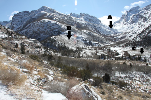
I like to imagine standing here long ago. Lamoille Canyon saw two glaciation events. During the earlier glaciation event, 150,000 years ago, the glacier flowing out of Right Fork Canyon (marked A on the above photo) merged with the glacier coming down the main canyon. Ice several hundred feet thick filled much of this canyon, and flowed downhill to emerge from the canyon mouth.
The more recent glaciation event, a mere 15,000 years ago, had glaciers that did not flow as far. The main canyon’s glacier stopped up canyon, perhaps less than a mile from this pull out. The glacier flowing out of Right Fork Canyon flowed past here, but got no farther than the next bend visible down canyon.
The lower canyon shows evidence of this fact. During the earlier ice age, ice gouged all of Lamoille Canyon into that classic U-shape, but that was 150,000 years ago. Since then, Lamoille Creek has carved the lower canyon back into a V-shape. But the canyon bottom in front of me was glacier-carved a second time only 15,000 years ago. It still retains its wide bottom.
A glacier’s ice is constantly melting, especially at these lower elevations. Melt water flows across the top, then cascades down through cracks in the ice and continues along the ground beneath a glacier. Tunnels beneath the ice fill with boulders, left behind as features called recessional moraines. These remain visible between here and the Lion’s Camp (C on the photo) as small, boulder-covered mounds. The camp’s athletic field is the scene of a small lake impounded by these recessional moraines.
Since only the Right Fork glacier continued past this spot, it left behind another visible glacial feature. Glaciers flowing down canyons melt more at their edges. Embedded rock debris falls free to pile up on the canyon walls. These produce lateral moraines, left behind as unnaturally smooth canyon walls (B on the photo.)
The lateral moraine left by the Right Fork glacier dammed the main canyon and probably created a small lake or pond upstream from here. Since then, Lamoille Creek has broken through that dam, but continues to cascade down its steep face. When the Lamoille Canyon Road were built, it needed to angle up the canyon wall behind me, to gain enough elevation to cross over this ancient moraine and continue into upper Lamoille Canyon. Once the road tops the moraine and turns up canyon, the glaciated canyon bottom allows the road to return to the wide canyon bottom.
It is a fascinating story visible from Lamoille Canyon’s glacier signs pull out.
Elko Daily Free Press, “Nature Notes”, 2/23/2012
© Gray Jay Press, Elko, NV
Return to Elko Nature Notes